Nature and climate
Location and transport
The east coast of Greenland is one of the most isolated areas in the Northern
Hemisphere, and it provides only little in terms of facilities or support
for field research. The nearest settlements, where the only rescue services
are to be found, are in Ammassalik and Ittoqqortoormiit (Scoresby Sund),
both around 400 km away. Since the loss of M/V Einar Mikkelsen in 1993,
there are no regular ship services on the coast. A local air-strip of around
1 km length has been established on a gravel plain in Sødalen approximately
15 km to the west of the intrusion and can be reached by twin-otter from
Iceland. Transport from Sødalen, however, needs to be arranged with
helicopter. Sea access is possible during the late summer months, and sheltered
anchorage can be found in Uttental Sund and Hjemsted Bugt. However, the
entrance to Uttental Sund is strewn with skerries and small islets which
prevent large ships from entering. The best passageway appears to be close
to the south coast of Kraemer Ø.
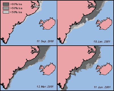 Unlike
Northern Europe and Iceland the climate of East Greenland does not benefit
from the warm Atlantic waters of the Gulf Stream. In contrast, the strong
East Greenland current provides the main drainage from the Arctic Ocean
and draws cold waters from the Polar region south along the coast. Usually
the transition from North Atlantic to Arctic conditions is abrupt and impressive.
It is marked by the appearance of sea ice and a new marine fauna. During
the winter and spring the sea ice can extend more than halfway across the
Denmark Strait creating an impassable barrier to ships, but the steady
melting during the summer means that the ice concentration is at its minimum
from the start of August to mid-October where it is normally limited to
sporadic icebergs. The cold East Greenland current is the single most important
factor for the climate, and the vegetation along most of the coast is minimal
trees and bushes being absent north of Skjoldungen several hundreds of
kilometres to the south.
Unlike
Northern Europe and Iceland the climate of East Greenland does not benefit
from the warm Atlantic waters of the Gulf Stream. In contrast, the strong
East Greenland current provides the main drainage from the Arctic Ocean
and draws cold waters from the Polar region south along the coast. Usually
the transition from North Atlantic to Arctic conditions is abrupt and impressive.
It is marked by the appearance of sea ice and a new marine fauna. During
the winter and spring the sea ice can extend more than halfway across the
Denmark Strait creating an impassable barrier to ships, but the steady
melting during the summer means that the ice concentration is at its minimum
from the start of August to mid-October where it is normally limited to
sporadic icebergs. The cold East Greenland current is the single most important
factor for the climate, and the vegetation along most of the coast is minimal
trees and bushes being absent north of Skjoldungen several hundreds of
kilometres to the south.
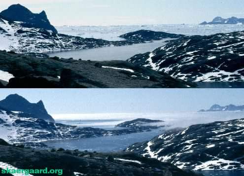 Summer
temperatures in the Skaergaard area are best described as chilly and warm.
Although generally there are many sunshine hours, chilly breezes and fogs
move in during the afternoon close to sea level. Rain can be expected during
the occasional passage of a depression, which generally takes from two
to three days, and good waterproofs are generally the only protection that
can be relied on. The Skaergaard area is barren and snow covered for 9-11
months of the year, and even during the summer period lakes and streams
may still be partially ice covered. Occasionally the area is subjected
to katabatic winds of hurricane force from inland (known locally as "piteraqs").
The winds are warm and dry and usually last a couple of hours during which
they pose a serious threat to tents and other light equipment. These winds
have generated a rich store of anecdotes, but occur rarely in the summer
months when field work is undertaken.
Summer
temperatures in the Skaergaard area are best described as chilly and warm.
Although generally there are many sunshine hours, chilly breezes and fogs
move in during the afternoon close to sea level. Rain can be expected during
the occasional passage of a depression, which generally takes from two
to three days, and good waterproofs are generally the only protection that
can be relied on. The Skaergaard area is barren and snow covered for 9-11
months of the year, and even during the summer period lakes and streams
may still be partially ice covered. Occasionally the area is subjected
to katabatic winds of hurricane force from inland (known locally as "piteraqs").
The winds are warm and dry and usually last a couple of hours during which
they pose a serious threat to tents and other light equipment. These winds
have generated a rich store of anecdotes, but occur rarely in the summer
months when field work is undertaken.
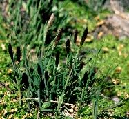 Vegetation in
the Skaergaard area is very scarce and consists mainly of mosses and low
hardy scrubs growing in sheltered areas between rocks. The most common
wildlife is arctic foxes and grouses with the occasional polar bear visiting
the area; in the sea there are seals and passing flocks of narwhales. As
a relief for Arctic travellers, the area is too cold for mosquitoes or
other insects to breed. Freshwater is readily available from the melting
snow and glaciers but the supply freezes up for most of the year and is
not steady enough to sustain an extensive plant life.
Vegetation in
the Skaergaard area is very scarce and consists mainly of mosses and low
hardy scrubs growing in sheltered areas between rocks. The most common
wildlife is arctic foxes and grouses with the occasional polar bear visiting
the area; in the sea there are seals and passing flocks of narwhales. As
a relief for Arctic travellers, the area is too cold for mosquitoes or
other insects to breed. Freshwater is readily available from the melting
snow and glaciers but the supply freezes up for most of the year and is
not steady enough to sustain an extensive plant life.
Administration and logistics
Research and recreational activities on Greenland are coordinated through
the Danish Polar Centre, and the mineral rights governed by the Bureau
of Minerals and Petroleum (Government of Greenland). Research and recreational
activities must be reported to the Danish Polar Centre, permissions are
required for foreign ships to enter the Greenlandic territorial waters,
for the use of firearms and radio equipment. If sample collection is required,
the necessary permits are needed from the mineral concession holders (the
Bureau of Minerals and Petroleum holds lists of concession holders). Commercial
sampling requires a concession.
Going to East Greenland? Take a look at the stuff
we pack here
Ice charts by courtesy of the National Ice Center, NOAA http://www.natice.noaa.gov,
accessed 25 July 2001.
© 2003 skaergaard.org